-
Title
-
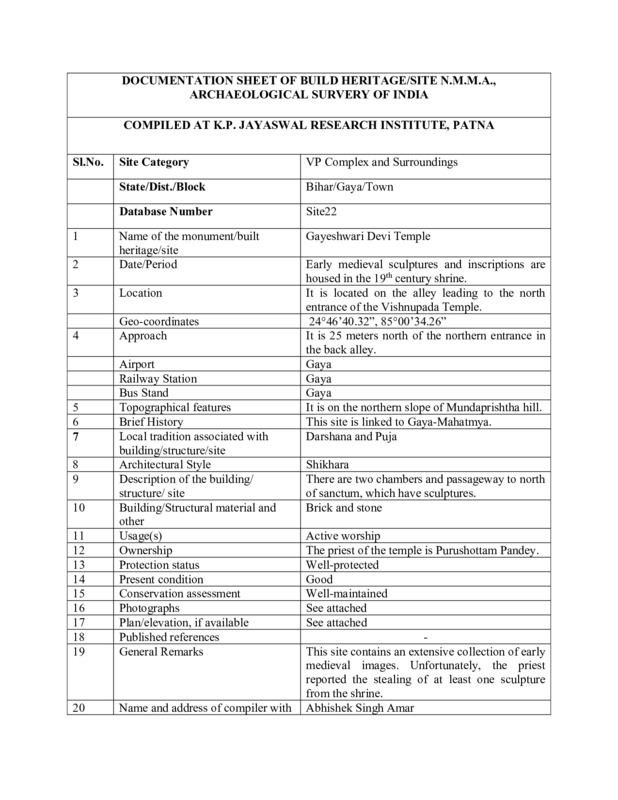
Documentation Sheet of Built Heritage/Site N.M.M.A., Archaeological Survey of India for Gayeshvari Temple
-
Subject
-
Hindu temples--India
-
Geographic coordinates (latitude, longitude)
-
24°46’40.32”, 85°00’34.26”
-
Local tradition
-
Darshan
-
Location
-
20-30 meters north of north entrance to Vishnupad in back alley
-
Topographical features
-
Northern slope of Mundaprshtha
-
Usage
-
Active worship
-
Structure
-
Two chambers and passageway to north of sanctum.
-
Approachs
-
20-30 meters north of north entrance to Vishnupad in back alley
-
Airport
-
Gaya
-
Building materials
-
Brick
-
stone
-
Railway station
-
Gaya
-
Bus stand
-
Gaya
-
Conservation assessment
-
Well-protected
-
Present condition
-
Good
-
Omeka identifier
-
sci-site22-KPJRForm.pdf
-
Site number
-
site22
-
Abstract
-
Good collection of early medieval images. Should be asked to register collection to avoid future theft.
-
Protection status
-
Good

 sci-site22-KPJRForm.pdf